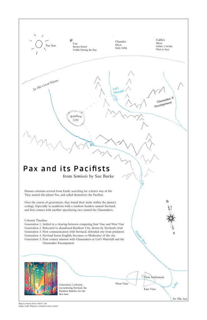
I wish I’d had this map when I was writing the novel Semiosis. I made a couple of my own maps, but this one is better.
It was made by Patrick Hixenbaugh, who got in touch with me:
“I’d like to share a map I made of the colonists’ journeys on Pax during the first novel, which I made for an assignment on literary maps for a college cartography course. We learned about maps for fictitious places, like Treasure Island and Narnia, and I thought of Pax right away. I thought you might like to have it, and see how accurately (or not!) it matches your vision of Pax.”
You got Pax exactly right, Patrick, and thank you for sharing it. Authors often rely on maps from real-life or imagination to orient the characters in their environments. For example, when characters travel to the mountains, they need to turn left at the bridge every time. This sounds easy, but when you’re writing a novel, every kind of mistake can creep in.
Patrick described his process for making the map:
***
What went into making my map? Well the first time I read Semiosis, the details like East and West Vine with the river flowing through it made it feel like a real place, especially when the colonists themselves talked about seeing the landscape from the sky and from satellite images. I had the mental picture of the river flowing up the mountains to Glassmaker City for a long time.
The course was an Introduction to Cartography for the geography/environmental science program at my college — I’m working towards a certificate in Geographic Information Systems (GIS). We studied some literary maps like what you’d find in Treasure Island and Tolkien, and were assigned to create a map in the same “literary” style — letting the map tell the story. I thought pretty quickly how much I’d love to see the map of Pax I’d been imagining.
I reread it once again just for fun and to get a general impression of the landscape, which reminded me of the lake, which eventually flows to a distant sea, and of the “Lief’s waterfall” area, where it turns out a lot of things happened! I thought a lot about the gates of the city, the bridge that Higgins destroyed in the eagle attack, but ended up not putting the bridge on the map since I wasn’t positive where it went.
I reread it a second time, really looking for the geographic details, and I loved picking up on everything that made Pax feel like an alien world — the strange moons with weird orbits and the sun’s brown dwarf companion star that rises and sets ahead of the sun. I realized they really ought to make it onto the map, so I drew them above the planet, in space. And I had to make a sizeable change to my mental map — I originally had thought the river that flowed through the colonists’ first area had led directly to the Rainbow City. But when I reread it, I found the place name “Thunder River” and got the impression that the pieces of bamboo and glass they recovered after the hurricane had not flowed directly past them, but had washed up on the shores of the lake instead. So I made Thunder River into a separate river that also flowed into the lake.
I had a lot of fun reading the trek from the parents’ colony to Rainbow City and sketching out where I thought the mountains and waterfalls were. I also picked up on a detail, that the city sat on a bluff above the river, which was really nice imagery I hadn’t picked up on before.
I also had a lot of fun with Nye’s first contact mission to the nomadic Glassmakers. The first time I read the novel I read it at the level of just feeling how arduous and dangerous their trek was. This time, reading through it and working out how their journey could map out into a plausible landscape was really interesting, and I got a lot out of that.
I finished the project this fall and went on to other things, but for winter break I read Interference again, and I noticed how the Coral Plains were always “south” of rainbow city, where I had always imagined them as “further up.” And that the Earthlings orbiting Pax found the colony in the Southern Hemisphere. That was a really cool discovery, and so I changed the North Arrow on the map to a South Arrow and had fun imagining life in the Southern Hemisphere, and thought about the rotation of solar systems and galaxies, and magnetic fields and how you would define north and south on an alien planet.
That does mean that east and west are reversed on my map! Just realized that now! Whoops! Was Rainbow City “north” of the parents’ settlement, or just upstream? Maybe the Pax colonists and the Earthlings used different references for north and south? I guess now I can reread Semiosis again and find out 🙂
